
Walk a Superior Street Record
A street-by-street search should build outward from one verified address. Superior and Douglas County records use several keys: the printed street address, tax key, legal description, owner name, and document number. Keep them together. The address gets you into the map and assessment roll, but the parcel key and legal description are stronger links when names or numbers change.
Ownership and occupancy are not the same. The assessor and a deed can name the title holder. A directory, voter record, or dated news item may support residence, but each is only a snapshot. Use this order for a careful Superior street directory search:
- Standardize the address, including its directional prefix and unit, then confirm the municipality.
- Search Douglas County and the property street address at Assessordata. Save the tax key and legal description.
- Open Beacon GIS to confirm the parcel shape, street, map date, and relevant public layers.
- Follow the owner name and legal description into LandShark, then check earlier instruments through county office resources.
- Add a dated directory, permit, archive item, or lawful voter-data source only when it answers the specific question.
Superior Street Search Fields
The City Assessor values and classifies property and acts as Real Property Lister for city parcels. Its free link goes to Assessordata. The public form asks for a county and either a property street address or tax key. Try exact variants such as a spelled-out direction and its short form. The live portal does not state its coverage date, so save the valuation year shown with any result.
| Visible field | Use in an address search | Important limit |
|---|---|---|
| County | Select Douglas County | A postal city does not settle jurisdiction |
| Property Street Address | Enter the situs address and test variants | Unit and directional forms can affect a match |
| Tax Key Number | Return to the same parcel with its stable key | A key identifies a parcel, not an occupant |
The 2025 assessment roll is a useful fallback when the live form fails. Its columns include owner, tax key, property description, property address, districts, class, acreage, and values. Rolls for 2021 through 2025 can show changes over time. They remain assessment snapshots, not a street roster.
Save the PDF page and row with each match. Compare the property address with the owner's mailing address, but do not read too much into either result. Matching addresses may support a working lead without proving occupancy. Different addresses are common for an absentee owner, estate, lender, trust, or organization. The roll can also show whether a parcel key, class, acreage, or value changed across the five posted years. It cannot replace the recorded transfer history. For that, carry the tax key and legal description into the Register of Deeds workflow. This separation keeps a street directory from turning an administrative owner field into a claim about a household.
Superior Address Points Come First
Superior's official Address Point layer was built for emergency dispatch, law enforcement, and land-use planning. That purpose makes it strong evidence that an address exists in a certain mapped place. It does not make the layer a people database. The city lets the public download the layer and identifies City Public Works as the address-number authority inside Superior.
Outside city limits, incorporated villages or Douglas County Zoning may control addressing. The Real Property Lister validates improvements with addresses. This city-county split matters near the Town of Superior, South Range, Poplar, and unincorporated land. Confirm the municipality before choosing an assessor, permit office, or records custodian.
Address rule. Treat the point as a mapped object, then seek dated records before attaching any person's name to it.
Map Superior Streets in Beacon
The City GIS guide describes a public viewer that can search, display, measure, and print parcel maps. Beacon GIS also connects map users with property information and switchable layers. Useful street context includes parcel polygons, roads, zoning, school and voting districts, parks, wetlands, and aerial photos. Exact controls can change because the viewer is dynamic.
Keep the situs address separate from an owner's mailing address. Record the map date and jurisdiction, too. A GIS boundary is good for orientation, while a legal boundary question belongs with a Wisconsin-licensed surveyor. For a whole street, scan parcel shapes and public infrastructure without copying a bulk list of names.
Superior Records Indexed by Address
No single Superior street directory settles who lives at every number. Each record set answers a narrower question. The strongest chain uses the same parcel key, legal description, and date across sources.
| Address source | Official keeper | Useful evidence | Access route |
|---|---|---|---|
| Assessment roll | City Assessor | Owner, tax key, situs, class, roll year | Assessordata or annual roll PDFs |
| Parcel map | City and County GIS | Parcel geometry, jurisdiction, public layers | Beacon GIS or GIS staff |
| Recorded land instruments | Douglas County Register of Deeds | Grantor, grantee, document and legal description | LandShark, courthouse terminal, tract books |
| Permits | City Building Inspection or county portal | Project type, date, applicant or contractor | Self Service Portal or records request |
| Historical address sources | Library and Historical Society | Dated names, addresses, plats and abstracts | Microfilm, onsite boxes, or request service |
Permit applications include building, electrical, mechanical, plumbing, sign, demolition, stormwater, and right-of-way work. An applicant or contractor is tied to the project, not necessarily to residence. When the live permit form does not expose an older entry, ask the city custodian for a narrow address and date range.
Wisconsin Public Records Law does not require a special request form. Superior routes city requests through its online system, but the Records Bureau also documents in-person, mail, and phone routes. Name the record class, address, project, and date span. Ask for existing electronic records and a cost estimate when needed. A focused request is more reproducible than asking an office to find everything tied to an address. County land records remain under separate custodians.
Superior Streets Meet the Deed Index
The Douglas County Register of Deeds keeps deeds, land contracts, mortgages, tax deeds, easements, and related instruments. LandShark is the online entry point, but it requires an account, and document images may carry charges even when index information is free. Public terminals are available at the courthouse. Tract-index books are not online.
The county lists image coverage through April 1961 for deeds, November 1960 for agreements, February 1951 for tax deeds, and September 1970 for corporations. Older records may still exist in books or office indexes. Call Land Records at 715-395-1570 or email landrecords@douglascountywi.gov when the web trail stops.
The successful manifest capture shows the county's real-estate access instructions:
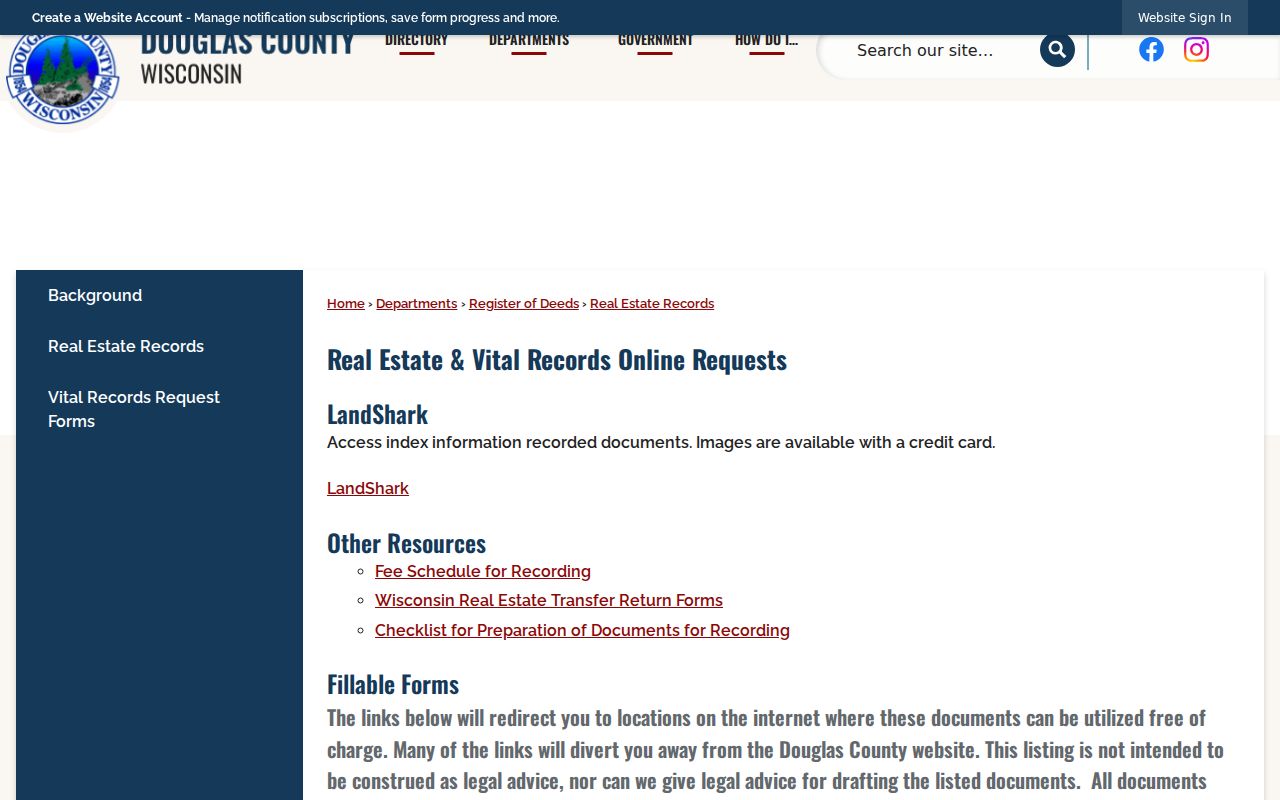
The page is the key check on which material is online, which images may be charged, and which tract books require office access.
Fix Superior Street Name Mismatches
Try directional forms, abbreviations, apartment or unit suffixes, and the address exactly as printed in the source. An old directory and the current address point may disagree. No official Superior street-renumbering chronology was located, so the mismatch alone does not prove a renumbering.
- Parcel
- A mapped piece of land identified by a tax key.
- Situs address
- The physical property address, which may differ from the owner's mailing address.
- Plat
- A recorded map that defines lots, blocks, and other land divisions.
- Criss-cross directory
- A directory arranged by street or address instead of only by surname.
Use a dated plat, deed, directory cross-reference, city archive item, or Public Works record to support a change. Preserve the old printed address, and label a modern equivalent as an inference until the link is proved.
Probe Superior Streets by Date
Superior's city archive can be searched by category, keyword, archive, time period, and date range. An old street name, cross street, parcel-related project, park, or public improvement can explain why an address changed. City Public Works records also appear in Douglas County Historical Society archive boxes 88 and 207.
For older land context, the society lists atlas and plat books in Box 25 and deeds and abstracts in Box 79. Its materials are held for onsite use and cannot be borrowed, though copies or scans may be available. Research requests were on hold when the source was checked, so verify that service before relying on a remote response.
Business Addresses on Superior Streets
A commercial address can create several name types: parcel owner, legal entity, license holder, permit applicant, and chamber member. Wisconsin DFI's corporate search can identify an entity and filing history, while the state credential search covers licensed people, organizations, and trades. Neither source proves that every listed person occupies the address.
Match the business name to the parcel, permit, and filing dates. An LLC, trust, estate, or mailing agent in an owner field may be valid. Follow its deed references and legal description instead of forcing a person's name into the record.
Limits of a Superior Street Directory
Public land records show title and administration, not a complete household. A deed may be old. The assessment owner may use a separate mailing address. A permit names a project contact. A historic directory may have gone to press before a move. MyVote is designed for a voter to inspect personal registration details, not for publishing a streetwide list.
Safe at Home protects an enrolled person's actual address from voter-roll inspection and provides an assigned address for agency use. Other fields may be redacted under Wisconsin law. A missing result may reflect privacy, a portal gap, a name variant, or a record held only at the counter.
Lawful use. Use address records for personal research, family history, civic curiosity, or scam prevention, never to stalk, harass, or intimidate anyone.